Importance Of Navigation Skills
Navigation skills are crucial in ensuring safety in the wilderness. Getting lost can lead to dangerous situations, injuries, or even fatalities. Knowing how to navigate reduces the risk of panic and ensures return to safety.
Without basic navigation skills, outdoor adventures might transform from enjoyable activities into stressful or hazardous experiences. These skills help in making informed decisions about directions and paths, preventing potential missteps. For instance, using a compass and map efficiently can help avoid disorientation.
Navigation skills enhance confidence. When individuals know how to read terrain features, they feel more in control and better prepared for unexpected scenarios. For example, recognizing landmarks or understanding topographical maps can make a significant difference when electronic devices fail.
Developing strong navigation skills also encourages self-reliance and a deeper connection with nature. Rather than depending on smartphones or GPS, understanding natural cues like the position of the sun or the flow of rivers fosters a sense of accomplishment and independence.
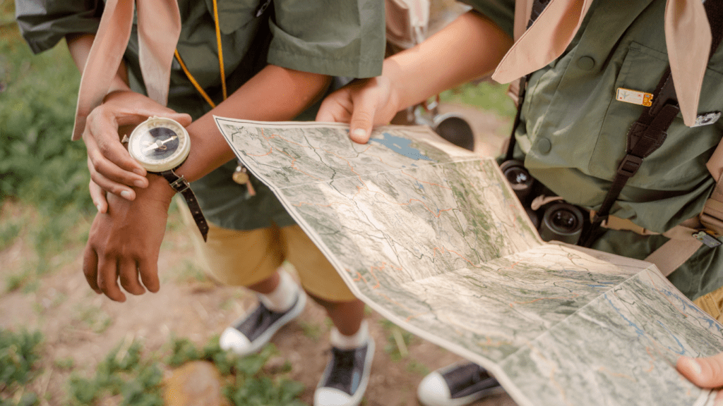
Essential Tools For Forest Navigation
Equipping yourself with the right tools is crucial for effective navigation in the forest. Here are some essential tools to consider.
Map And Compass
A topographic map and a reliable compass are indispensable. Maps offer a detailed layout of the terrain using contour lines, symbols, and colors to highlight various features. Compasses provide a directional reference, helping you orient yourself in relation to your map. Familiarizing yourself with map-reading and compass-use techniques ensures accurate navigation, even when electronic devices fail.
GPS Devices
Handheld GPS devices are invaluable, especially in dense forests where visibility is limited. These devices use satellite signals to determine your exact location, displaying it on a digital map. Many models also include features like waypoint marking, route tracking, and geocaching support. Regularly updating the device’s software and map databases enhances accuracy.
Smartphone Applications
Smartphone applications offer a convenient alternative, integrating GPS functionality with modern user interfaces. Apps like Gaia GPS, AllTrails, and ViewRanger provide detailed maps, offline access, and user-friendly navigation tools. However, reliance on smartphones entails ensuring your device is fully charged and carrying backup power sources like portable chargers.
Reading A Map
Using a map effectively is a fundamental skill for forest navigation. By understanding map symbols and interpreting contour lines, you can traverse the terrain confidently.
Understanding Map Symbols
Map symbols represent various features in the landscape. Familiarize yourself with the legend found on the map’s edge. Common symbols include:
- Trailheads: Represented by dots or small icons.
- Water sources: Shown as blue lines or polygons, indicating streams, rivers, or lakes.
- Vegetation: Green shading or symbols indicate forested areas or types of vegetation.
- Man-made structures: Black symbols for buildings, roads, and bridges.
Recognizing these helps identify critical waypoints and navigate effectively.
Interpreting Contour Lines
Contour lines depict elevation and landscape shape. Lines closer together indicate steep terrain, while those farther apart show gentle slopes. Key points to remember:
- Peaks: Circles with the highest point at the center.
- Valleys: V-shaped lines pointing upstream or uphill.
- Ridges: U or V-shaped lines pointing downhill.
By mastering contour lines, you can understand elevation changes and navigate complex terrains.
Using A Compass
A compass remains an essential tool for forest navigation. Understanding its features and knowing how to take a bearing can significantly enhance your ability to navigate through the wilderness.
Basic Compass Features
A compass typically has several fundamental components. The following features are crucial for effective use:
- Magnetic Needle: The magnetic needle always points to magnetic north. In dense forests, this helps you orient your map correctly.
- Rotating Bezel: The bezel, marked in degrees, allows you to set a specific bearing. Turning the bezel aligns with the intended direction of travel.
- Orienteering Lines: These lines on the base plate help align the compass with map features, like grid lines or the edge of the map.
- Base Plate: The transparent base plate, often marked with a ruler, facilitates map reading and plotting routes.
- Direction of Travel Arrow: This arrow on the base plate points in the direction you should move once the compass is set.
- Align the Map: Place the compass on the map with the base plate edge along your path. Ensure the orienteering lines are parallel to the map’s grid lines.
- Set the Bezel: Rotate the bezel until the orienting arrow and lines point to magnetic north.
- Take the Bearing: Hold the compass flat in your hand, ensuring the base plate and direction of travel arrow point forward. Turn your body, keeping the compass still, until the magnetic needle aligns with the orienting arrow.
- Follow the Bearing: Move in the direction the travel arrow points, keeping the needle aligned with the orienting arrow, ensuring you remain on your intended path.
Combining Map And Compass


Using a map and compass together is essential for forest navigation, ensuring accuracy and safety when exploring. I’ll cover key techniques to improve navigation skills.
Orienting The Map
First, align the map with the compass to match the terrain. Place the map on a flat surface. Rotate it until the north on the map aligns with the magnetic north indicated on the compass needle. This step helps ensure that features on the map correspond correctly to their real-world counterparts.
Plotting A Course
Next, plot a course to navigate effectively. Identify your starting and ending points on the map. Place the edge of the compass base plate between these points. Rotate the bezel so that the orienting lines are parallel to the map’s grid lines, pointing north. Now, take a bearing by reading the degrees at the index line. Follow this bearing with your compass to navigate your chosen path.
Natural Navigation Techniques
Natural navigation offers a range of methods to find one’s way in the forest without relying on electronic devices. Leveraging the sun, stars, and natural landmarks makes it possible to navigate with confidence.
Using The Sun And Shadows
The sun’s position can help determine direction. In the northern hemisphere, the sun rises in the east and sets in the west. Midday, the sun is in the southern part of the sky. As a practical tip, one can use a shadow stick: place a stick upright in the ground and mark the tip of its shadow. After 15 minutes, mark the new position of the shadow tip. Drawing a line between the two marks points east to west, with the first mark being west.
Reading The Stars
Stars provide reliable navigation cues at night. The North Star, Polaris, is crucial since it remains in a fixed position above the northern horizon. To find Polaris, locate the Big Dipper constellation and follow the line formed by its outer edge stars. Polaris lies along this line. Using this star, one can determine true north, aiding nocturnal navigation.
Observing Natural Landmarks
Natural landmarks such as mountains, rivers, and distinct trees offer valuable reference points. Visualizing the terrain and recognizing unique features help create a mental map. For instance, if one knows a river flows westward, following it can help maintain a general westward direction. Similarly, distinct rock formations or unusual tree shapes serve as consistent waypoints, enhancing navigation accuracy.
Safety Tips For Forest Navigation
Staying safe in the forest involves careful planning and adherence to key guidelines. Proper preparation, awareness, and response strategies ensure effective forest navigation.
Preparing For The Hike
Preparation begins before setting foot in the forest. I always inform someone of my plans, including my route, expected time of return, and any contingency plans. This ensures that help can be mobilized if needed.
Packing essential items is crucial. I carry the following:
- Topographic Map and Compass: Primary navigation tools.
- Handheld GPS and Smartphone: For backup, along with extra batteries or a power bank.
- Water and Food: Sufficient amounts for the entire trip and extra in case of emergencies.
- First Aid Kit: Includes bandages, antiseptics, and any necessary medications.
- Whistle and Signal Mirror: For attracting attention if lost.
- Proper Clothing and Footwear: Suitable for the weather and terrain to avoid injury.
I also check the weather forecast and study the terrain beforehand. Understanding trail conditions helps me prepare for potential challenges like steep slopes or water crossings.
What To Do If You Get Lost
Even with preparation, getting lost can happen. I stay calm and think through my situation. Panicking can lead to poor decisions.
I follow these steps:
- Stop and Stay Put: This conserves energy and avoids getting more lost.
- Assess My Resources: I inventory my supplies and determine how long they can sustain me.
- Signal for Help: Using a whistle or signal mirror to attract attention.
- Reevaluate My Last Known Position: Using my map and compass, I try to backtrack to a familiar location.
- Create a Shelter: If nightfall or bad weather is imminent, I prioritize creating a shelter to stay safe.
Mentally prepared and equipped with the right tools, my chances of navigating safely—even if lost—are significantly improved.